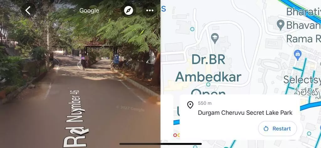
'Google eye from the sky' will now guide you on the street
Ever imagined, the 'Google eye from the sky' will one day walk you along the thoroughfares that you tread everyday?

HYDERABAD: Ever imagined, the 'Google eye from the sky' will one day descend right next to you, walk you along the thoroughfares that you tread everyday? Though the description sounds a little surreal, this has become absolutely true and for everyone to see and believe..!
The street view of Google Maps, a case of sour grapes for us in India so far, is now a reality. Next time when you tap the button on the app and zero in on a location, your experience will not be the same as it was before, zooming around the lifeless blocs in concrete jungle. Every landmark worth its name that you will try to locate – be it your favourite food joint, school, college, hospital or even the non-descript dusty by-lanes – you will be treated with stunning imagery. With little exaggeration, the Google street view will come with the finesse and quality that even your naked eye may fail to capture at times.
The panoramic view with the 360-degree tilt only provides the icing on the cake for the Google Maps users.
Google Maps has launched its street view service across 10 cities in India in partnership with two local companies. So far, the street view option is available outside India and is very popular with the Maps users worldwide. But here is a little twist, which is a first of its kind. In its India launch, Google is not capturing the data itself for street view and instead is relying on the imagery provided by its two partners.
In a statement, Google said that the Street View was being launched in partnership with Genesys International and Tech Mahindra.
"Street view will be available on Google Maps with fresh imagery licensed from local partners covering over 1,50,000 km across 10 cities in India, including Bengaluru, Chennai, Delhi, Mumbai, Hyderabad, Pune, Nashik, Vadodara, Ahmednagar and Amritsar," the statement said.
The long-term plan is to expand this facility to more than 50 cities by the end of 2022. Interestingly, for a tech-savvy population that fast laps up tech innovations, the Google Maps Street View ironically comes a bit too late into India. But then, the delay so far can only be attributed to the Indian government's hesitance in exposing the panoramic images of roads and other sites due to security concerns.
As an added feather in the cap, the app is also showing the speed limits data shared by the traffic authorities, beginning with Bengaluru and Chandigarh.
As part of a pilot project, the tech behemoth has forged a partnership with the Bengaluru traffic police to help optimize the traffic light timings. Interestingly, the experiment yielded a 20-percent reduction in traffic congestion across all the intersections. This has bolstered Google to scale it across the garden city and expand the pilot to even Hyderabad and Kolkata in the coming months.
What's more, eight cities – Delhi, Hyderabad, Chandigarh, Ahmedabad, Kolkata, Burgaon, Bengaluru and Agra -- are now set to get alerts on road closures and incidents in Google Maps.
Within days of its implementation, the street view is already leaving its users mesmerized in Hyderabad. "I am amazed to find even a puddle of stagnant water on the road behind my house and the cars parked outside. This is simply brilliant," said Vijayesh, a young techie.
Street view option, boon or bane?
Interestingly, on a technical note, Google is only re-launching the street view feature in India now. Way back in 2011, the panoramic street view imagery was made available on Google Maps. But it soon sparked fears that the feature could become a handy tool for anti-national and terror elements to get hold of sensitive information pertaining to the defence sector with minimum fuss. In view of the objections raised, the Union government prohibited Google Maps from using the street view facility in 2016.
Now, re-launching the feature after six years, Google has tied up with Tech Mahindra to ensure that the facility conformed to all the guidelines of the Union government. As part of the fresh initiative, Tech Mahindra has been collecting the street view imagery using cameras mounted atop Scorpio SUVs.
But this has not helped much in preventing the fears of the past from resurfacing. To alleviate these concerns, Google has decided to exclude high security zones and key government, military and defence installations that perennially need to be under the cover of secrecy and privacy. To pre-empt security threats, IT experts also recommend masking of the street view at some places as a viable option.
While there is no cognizable and imminent threat to the military and defence installations, the street view is likely to alter the threat perception in residential areas with a fresh set of challenges. The biggest of them all stems from the clarity of the imagery and the vantage view it provides of the colonies.
It is widely feared that the street view would work to the advantage of burglars and robbery gangs to easily choose and locate their most ideal targets. Vital information like the height and type of main gates, location of doors and windows and density of houses in a colony will also be easily deciphered. In a nutshell, a recce done entirely on Google Maps, without having to break a sweat!
But then, this is the flipside of concerns which the tech giant is expected to carefully examine in due course and come up with fool-proof solutions. The broader objective is to provide the Maps users with that 'in-the-street' experience and help them view and locate their addresses through the panoramic lens of Google. Hopefully, the street view will achieve that while effectively allaying the fears on the security front.


